


YOUR NEXT
ADVENTURE
looking forward to
YOUR NEXT
ADVENTURE
looking forward to
YOUR NEXT
ADVENTURE
looking forward to

ACTIVITIES
.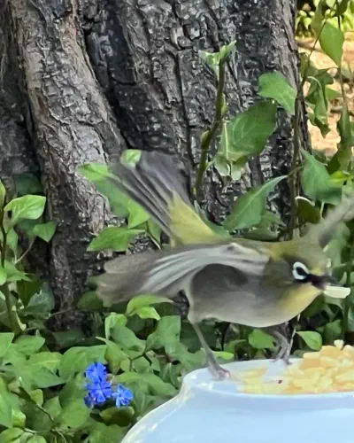
Bird Watching
Hiking Trails
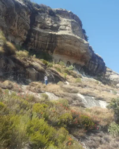
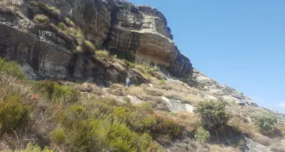
SHORT HIKING TRIPS IN AND AROUND MEIRINGSKLOOF Most trails have steps; reasonable mobility and fitness is required Holkrans Quick Hike: Round trip: 40 min – 1 hr. This short hike is for those who have limited time, or who find steps difficult. Start from the office, follow the car road, turn up left up with the paving, and follow the footpath where it says Hiking Trails Start Here. It is uneven but a fairly easy hike all the way to the small dam. Cross the steel bridge, and hike uphill until you reach the Holkrans (there are some steps, just rest and keep going until you reach Hokrans, it is worth it). Pass through Holkrans and hike until you get to the Chain Ladder. Admire the beautiful scenery. Take photos. Return the same way. Circular Cave Hike: Round trip: 1 hr 30 min. Scenic hike with many steps. Spruitroete, Ouhout Walk, Boesmangrot, Holkrans, Chain Ladder / Jacob’s Ladder, left along the top of the Cliff, back down into Meiringskloof. Start with Spruitroete near the Office. Hike down to Meiringspruit, follow the stream to the first wooden bridge, turn right, then left on Ouhout Walk, take the Boesmangrot turn-off, and hike uphill to reach Boesmangrot. Exit Boesmangrot on the other side and hike down to the main footpath. Turn right to Holkrans. Exit Holkrans on the far end and continue to reach Jacob’s Ladder and the Chain Ladder; both can be used to climb to the top of the cliff. At the top of the cliff turn left, follow the white marks painted on the rocks, and hike down to Meiringskloof where the board indicates. Turn right on Castle View, left at the T-junction and down to where the chalets and camping are. Boesmangrot has an interesting stalagmite column formed by mineral deposits, a dainty waterfall from the springs above, a few intact Khoisan paintings, and at shoulder height a layer in the rock with small white bone fragments and carbonized plants from the dinosaur period when animals and plants were crushed by volcanic activity. Holkrans is a very impressive open cave 100m in length, up to 40m deep. In Holkrans there are some stinging nettles/brandnetels (plants with small jagged-edged leaves – don’t touch !) Water Tunnels: Round trip: 2 - 3 hrs (7 km). The water tunnels were formed by water erosion over many years, and are located at the inflow to the Fouriesburg dam on top of the cliffs. (1) For the most scenic hike follow the Circular Cave Hike to reach Holkrans. Pass through Holkrans & climb to the top of the cliff (Chain Ladder, or Jacob’s Ladder), OR (2) Start from the office, follow the car road, turn left at the paving, take Hiking Trails Start Here footpath, left onto Maanskerm turn- off, right at Castle View turn-off, left at the T-junction. hike steep uphill. For either option: at the top of the cliff turn right, follow the white marks on the sandstone until you reach the car road, turn right, cross the bridge, and hike along the right- side of the dam to reach the inflow at the top-end of the dam. At the flat piece of sandstone with a pile of rocks (the 4x4 road ends there), climb down to the dam’s feeder stream. Turn right and continue until you see the fallen tree stump and rocks. The main stream opens up to a very interesting rock ceiling carved out by water. The small stream to the right has an icy cold (arctic) pool and a small waterfall – be careful – rocks are slippery when wet! Return along the side of the dam, over the car bridge & turn left back to the cliff edge. Pass the Chain Ladder and Jacob’s Ladder boards, hike along the cliff edge, then down to Meiringskloof where indicated. Right onto Castle View, left at the T-junction, and down to the main footpath. Maanskerm (Moon Veil): Way back a landscape student hung many long bamboo poles as a veil in front of the cave. The poles formed a giant wind chime and had a big white circle painted on them like a moon. Castle View: This short scenic hike offers beautiful views over the Maluti Mountains. Look across the cultivated field and try to spot Destiny Castle (a replica of a medieval castle) in the far distance. Spruitroete: A beautiful short hike that crosses Meiringspruit three times. Ouhout Walk: There are many Ouhout / Old Wood Trees. The bark looks old and flaky, hence the name. Cross on the Cliff: Standing at the cross one has beautiful views over Meiringskloof, the Maluti mountains, and the mountains to the west. The Cliff Hanger Trail start here (a permit is required from the office). Swaeltjie Nes: An off-grid rustic mountain hut that can be booked for exclusive use by one group. If the notices on the gates say: Residents Only. Please do not enter. People are staying there. When nobody is staying there you are welcome to hike past and have a look. ZigZag Rock Passage: Take a walk through the rock. Extraordinary – well worth the visit !! Sunset Trail: The trail to hike late afternoon when the sun has disappeared behind the mountains to the west – no sun at the chalets, but this trail is still basked in sun : -) CLIFF HANGER HIKING TRAIL (9.2 – 12.2km; 4-7 hrs) (Circular trail – starts and ends in Meiringskloof) Start with Spruitroete near the office in Meiringskloof. At the first wooden bridge turn right and hike up to the Cross-on-the-Cliff (30 min). Follow the hiking trail with its white paint marks which initially follows the contours some distance from the cliff edge, with sheer drops on the right-hand side and steep inclines to the mountain tops on the left. Be careful – black marks on sandstone can be slippery when wet. Many different plant species can be seen along the way such as watsonias, tea bushes, everlasting flowers (“sewejaartjies”), sugar bushes, cabbage trees, and a variety of heather plants (“erikas en heide”). Enjoy the magnificent views to the west (Wolhuterskop), south (Witteberge / Visierskerf) and south-east / east (Maluti Mountain Range). After about 2 to 3 hrs / 5 kms the trail joins an abandoned 4x4 trail for a fairly steep incline, flattening out, and then dropping down to a plateau with many gwarrie trees. From the plateau the trail descends towards the Fouriesburg dam, first veering to the right in front of the small hill, and then it continues down through a farm gate to the inflow of the dam. For the Water Tunnels follow the white marks down from the flat sandstone area to reach the water stream below, turn right, wade a short distance through the water to get past the rock and continue. Cool down in the icy cold “arctic” pool in the small stream to the right, or simply take some special photographs. Exit the Water Tunnels at the same place where you came in. To return to Meiringskloof walk along the edge of the dam following the white paint markings. Once past the dam wall, cross the car bridge over the ravine, then turn left towards the edge of the cliff bordering Meiringskloof. Either (1) climb down the Chain Ladder or Jacob’s Ladder and pass through the Holkrans (Hollow Cave), follow the footpath down to the chalets and camping sites (with an optional short detour through Boesmangrot on the way down); or (2) stay on top of the cliff, follow the white paint marks until the Footpath Down bord is reached, and hike down into Meiringskloof via Kruinroete. 1. Cross-on-the-Cliff. Stop and view Meiringskloof and Fouriesburg from the top. 2. Clump of Pine Trees. Rest a while and enjoy the views over the Witteberge to the west / south-west. Try to spot the mountain ridge called Visierskerf – it looks like the V-shaped sight of a gun. Look out for the watsonias, heather plants (Rooiheide), and some herbal tea bushes. 3. Corner Cliff Outlook. Look down onto the game farm and landing strip below. Further away, next to the road to Clarens, is the dam used for the Annual Polar Bear Plunge. Even more south is a break in the mountains – this is Calendonspoort Border Post with Lesotho. Follow the mountain ridge and glance to the right / south-west, to spot Destiny Castle on a mountain ridge. 4. This vantage point provides a good view of the protruding mountain rock called Queen Victoria (listed as one of the 20 highest loose-standing rock formations in the Free State, and resembling the seated monarch), the Brandwaterkom (the area bordered by the Caledon River, Witteberge and Rooiberge; conquered territory that was originally part of Lesotho), Lesotho and the Maluti Mountains (with an altitude of up to 3482m). 5. Here the trail traverses many sugarbush trees and herbal tea plants. 6. The outcrop of fallen rocks on the left side of the trail was an impressive rock finger which crashed down some years ago during a heavy rainstorm. Join the abandoned Lekeke Lefika (leaning / askew rock) 4x4 track to hike up to the ridge, cross over and hike down to the plateau with its gwarrie trees, a total hike of about 3-4 hrs from Meiringskloof. 7. The plateau with its gwarrie trees is a good place to stop for lunch in the shade. The highest mountain tops seen to the east / north-east are Ventersberg and Snymanshoek, both in the Rooiberge mountain-range, which forms part of the foothills of the Drakensberg. 8. The Water Tunnels are located at the inflow to the municipal dam and were formed over many years of water and soil erosion. The pile of rocks was a car bridge before it collapsed. 9. The dam provides Fouriesburg with water as an alternative to the Caledon River. 10. The hollow cave is impressive – about 100m in length and 40m deep in the widest part. 11. In the Boesmangrot spot the ancient top-to-bottom stalagmite/column; look for the remaining intact paintings (animals & men) & find the shoulder high layer with white bone fragments.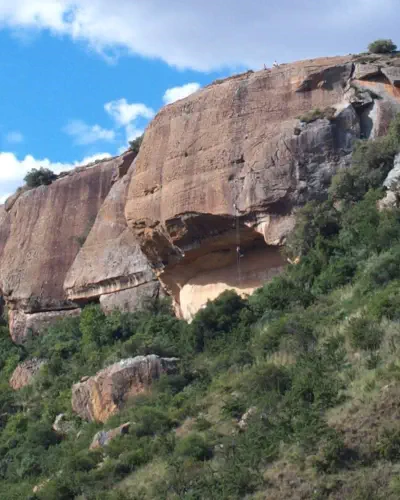
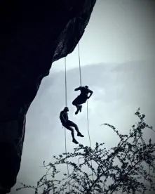
Abseiling
Book Directly with:Willem 083 891 5515 The more the merrier, and cheaper……time!!!! Guests…. Entrance fee of R30/adult and R20/child


MEIRINGSKLOOF
NATURE PARK


YOUR NEXT
ADVENTURE
looking forward to
YOUR NEXT
ADVENTURE
looking forward to
YOUR NEXT
ADVENTURE
looking forward to
ACTIVITIES
.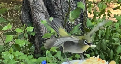
Bird Watching
Hiking Trails
SHORT HIKING TRIPS IN AND AROUND MEIRINGSKLOOF Most trails have steps; reasonable mobility and fitness is required Holkrans Quick Hike: Round trip: 40 min – 1 hr. This short hike is for those who have limited time, or who find steps difficult. Start from the office, follow the car road, turn up left up with the paving, and follow the footpath where it says Hiking Trails Start Here. It is uneven but a fairly easy hike all the way to the small dam. Cross the steel bridge, and hike uphill until you reach the Holkrans (there are some steps, just rest and keep going until you reach Hokrans, it is worth it). Pass through Holkrans and hike until you get to the Chain Ladder. Admire the beautiful scenery. Take photos. Return the same way. Circular Cave Hike: Round trip: 1 hr 30 min. Scenic hike with many steps. Spruitroete, Ouhout Walk, Boesmangrot, Holkrans, Chain Ladder / Jacob’s Ladder, left along the top of the Cliff, back down into Meiringskloof. Start with Spruitroete near the Office. Hike down to Meiringspruit, follow the stream to the first wooden bridge, turn right, then left on Ouhout Walk, take the Boesmangrot turn-off, and hike uphill to reach Boesmangrot. Exit Boesmangrot on the other side and hike down to the main footpath. Turn right to Holkrans. Exit Holkrans on the far end and continue to reach Jacob’s Ladder and the Chain Ladder; both can be used to climb to the top of the cliff. At the top of the cliff turn left, follow the white marks painted on the rocks, and hike down to Meiringskloof where the board indicates. Turn right on Castle View, left at the T-junction and down to where the chalets and camping are. Boesmangrot has an interesting stalagmite column formed by mineral deposits, a dainty waterfall from the springs above, a few intact Khoisan paintings, and at shoulder height a layer in the rock with small white bone fragments and carbonized plants from the dinosaur period when animals and plants were crushed by volcanic activity. Holkrans is a very impressive open cave 100m in length, up to 40m deep. In Holkrans there are some stinging nettles/brandnetels (plants with small jagged-edged leaves – don’t touch !) Water Tunnels: Round trip: 2 - 3 hrs (7 km). The water tunnels were formed by water erosion over many years, and are located at the inflow to the Fouriesburg dam on top of the cliffs. (1) For the most scenic hike follow the Circular Cave Hike to reach Holkrans. Pass through Holkrans & climb to the top of the cliff (Chain Ladder, or Jacob’s Ladder), OR (2) Start from the office, follow the car road, turn left at the paving, take Hiking Trails Start Here footpath, left onto Maanskerm turn-off, right at Castle View turn-off, left at the T- junction. hike steep uphill. For either option: at the top of the cliff turn right, follow the white marks on the sandstone until you reach the car road, turn right, cross the bridge, and hike along the right-side of the dam to reach the inflow at the top-end of the dam. At the flat piece of sandstone with a pile of rocks (the 4x4 road ends there), climb down to the dam’s feeder stream. Turn right and continue until you see the fallen tree stump and rocks. The main stream opens up to a very interesting rock ceiling carved out by water. The small stream to the right has an icy cold (arctic) pool and a small waterfall – be careful – rocks are slippery when wet! Return along the side of the dam, over the car bridge & turn left back to the cliff edge. Pass the Chain Ladder and Jacob’s Ladder boards, hike along the cliff edge, then down to Meiringskloof where indicated. Right onto Castle View, left at the T-junction, and down to the main footpath. Maanskerm (Moon Veil): Way back a landscape student hung many long bamboo poles as a veil in front of the cave. The poles formed a giant wind chime and had a big white circle painted on them like a moon. Castle View: This short scenic hike offers beautiful views over the Maluti Mountains. Look across the cultivated field and try to spot Destiny Castle (a replica of a medieval castle) in the far distance. Spruitroete: A beautiful short hike that crosses Meiringspruit three times. Ouhout Walk: There are many Ouhout / Old Wood Trees. The bark looks old and flaky, hence the name. Cross on the Cliff: Standing at the cross one has beautiful views over Meiringskloof, the Maluti mountains, and the mountains to the west. The Cliff Hanger Trail start here (a permit is required from the office). Swaeltjie Nes: An off-grid rustic mountain hut that can be booked for exclusive use by one group. If the notices on the gates say: Residents Only. Please do not enter. People are staying there. When nobody is staying there you are welcome to hike past and have a look. ZigZag Rock Passage: Take a walk through the rock. Extraordinary – well worth the visit !! Sunset Trail: The trail to hike late afternoon when the sun has disappeared behind the mountains to the west – no sun at the chalets, but this trail is still basked in sun : -) CLIFF HANGER HIKING TRAIL (9.2 – 12.2km; 4-7 hrs) (Circular trail – starts and ends in Meiringskloof) Start with Spruitroete near the office in Meiringskloof. At the first wooden bridge turn right and hike up to the Cross-on-the-Cliff (30 min). Follow the hiking trail with its white paint marks which initially follows the contours some distance from the cliff edge, with sheer drops on the right-hand side and steep inclines to the mountain tops on the left. Be careful – black marks on sandstone can be slippery when wet. Many different plant species can be seen along the way such as watsonias, tea bushes, everlasting flowers (“sewejaartjies”), sugar bushes, cabbage trees, and a variety of heather plants (“erikas en heide”). Enjoy the magnificent views to the west (Wolhuterskop), south (Witteberge / Visierskerf) and south-east / east (Maluti Mountain Range). After about 2 to 3 hrs / 5 kms the trail joins an abandoned 4x4 trail for a fairly steep incline, flattening out, and then dropping down to a plateau with many gwarrie trees. From the plateau the trail descends towards the Fouriesburg dam, first veering to the right in front of the small hill, and then it continues down through a farm gate to the inflow of the dam. For the Water Tunnels follow the white marks down from the flat sandstone area to reach the water stream below, turn right, wade a short distance through the water to get past the rock and continue. Cool down in the icy cold “arctic” pool in the small stream to the right, or simply take some special photographs. Exit the Water Tunnels at the same place where you came in. To return to Meiringskloof walk along the edge of the dam following the white paint markings. Once past the dam wall, cross the car bridge over the ravine, then turn left towards the edge of the cliff bordering Meiringskloof. Either (1) climb down the Chain Ladder or Jacob’s Ladder and pass through the Holkrans (Hollow Cave), follow the footpath down to the chalets and camping sites (with an optional short detour through Boesmangrot on the way down); or (2) stay on top of the cliff, follow the white paint marks until the Footpath Down bord is reached, and hike down into Meiringskloof via Kruinroete. 1. Cross-on-the-Cliff. Stop and view Meiringskloof and Fouriesburg from the top. 2. Clump of Pine Trees. Rest a while and enjoy the views over the Witteberge to the west / south-west. Try to spot the mountain ridge called Visierskerf – it looks like the V-shaped sight of a gun. Look out for the watsonias, heather plants (Rooiheide), and some herbal tea bushes. 3. Corner Cliff Outlook. Look down onto the game farm and landing strip below. Further away, next to the road to Clarens, is the dam used for the Annual Polar Bear Plunge. Even more south is a break in the mountains – this is Calendonspoort Border Post with Lesotho. Follow the mountain ridge and glance to the right / south-west, to spot Destiny Castle on a mountain ridge. 4. This vantage point provides a good view of the protruding mountain rock called Queen Victoria (listed as one of the 20 highest loose-standing rock formations in the Free State, and resembling the seated monarch), the Brandwaterkom (the area bordered by the Caledon River, Witteberge and Rooiberge; conquered territory that was originally part of Lesotho), Lesotho and the Maluti Mountains (with an altitude of up to 3482m). 5. Here the trail traverses many sugarbush trees and herbal tea plants. 6. The outcrop of fallen rocks on the left side of the trail was an impressive rock finger which crashed down some years ago during a heavy rainstorm. Join the abandoned Lekeke Lefika (leaning / askew rock) 4x4 track to hike up to the ridge, cross over and hike down to the plateau with its gwarrie trees, a total hike of about 3-4 hrs from Meiringskloof. 7. The plateau with its gwarrie trees is a good place to stop for lunch in the shade. The highest mountain tops seen to the east / north-east are Ventersberg and Snymanshoek, both in the Rooiberge mountain- range, which forms part of the foothills of the Drakensberg. 8. The Water Tunnels are located at the inflow to the municipal dam and were formed over many years of water and soil erosion. The pile of rocks was a car bridge before it collapsed. 9. The dam provides Fouriesburg with water as an alternative to the Caledon River. 10. The hollow cave is impressive – about 100m in length and 40m deep in the widest part. 11. In the Boesmangrot spot the ancient top-to- bottom stalagmite/column; look for the remaining intact paintings (animals & men) & find the shoulder high layer with white bone fragments.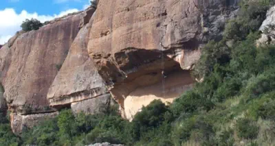
Abseiling
Book Directly with:Willem 083 891 5515 The more the merrier, and cheaper……time!!!! Guests…. Entrance fee of R30/adult and R20/child


MEIRINGSKLOOF
NATURE PARK